Tompkinsville East Bypass Map
2017-11-13 - Monroe County, KY - Photo from Wes Watt, KYTC, Bowling Green, KY
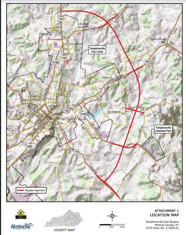
The bypass is a section of roadway approximately four miles long that connects KY 163 (Celina Road) near Jane Yokley Cemetery Road with KY 163 (Edmonton Road) across from Ben Hall Road. The roadway is a new route featuring a two-lane roadway with turning lanes at intersections. The bypass will create new intersections with Capp Harlan Road, Cave Springs Road, KY 100 (Center Point Road), and KY 1049 (Radio Station Road). The project will provide a new north-south alternative route which will help reduce large truck and commercial traffic in downtown Tompkinsville. In addition, the bypass will relieve traffic congestion in downtown Tompkinsville and give a faster route to emergency and first responders. - Wes Watt Comments | Permalink
2017-11-13 - Monroe County, KY - Photo from Wes Watt, KYTC, Bowling Green, KY
The bypass is a section of roadway approximately four miles long that connects KY 163 (Celina Road) near Jane Yokley Cemetery Road with KY 163 (Edmonton Road) across from Ben Hall Road. The roadway is a new route featuring a two-lane roadway with turning lanes at intersections. The bypass will create new intersections with Capp Harlan Road, Cave Springs Road, KY 100 (Center Point Road), and KY 1049 (Radio Station Road). The project will provide a new north-south alternative route which will help reduce large truck and commercial traffic in downtown Tompkinsville. In addition, the bypass will relieve traffic congestion in downtown Tompkinsville and give a faster route to emergency and first responders. - Wes Watt Comments | Permalink